A Place-Name Walk Through an Old Town
A place-name walk through an old town helps you read street and district names as clues to local history, without mistaking them for proof.
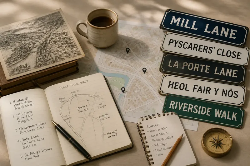
Why does one street in an old town have three names on the map, while a nearby lane seems to say nothing at all? A place-name walk through an old town can help you read those differences as clues to local history, provided you treat each name as a question rather than a verdict. The useful work is not spotting an exotic-looking word; it is noticing where a name appears, what it sits beside and which explanations remain possible.
This walk is designed for the snags that tend to derail a curious visitor: unclear spellings, seductive folk stories, vanished landmarks and maps that disagree. Choose a compact area with streets, a square and at least one district name. Bring a small notebook or use a map app for notes, but keep your route on public paths. The place itself is the subject; there is no need to turn a pavement into an archaeological trench.
Start with a small area
A sprawling route makes names blur together. Pick a town centre or a neighbourhood you can cross on foot, ideally one where street signs are visible and a public map labels both streets and districts. Begin at a recognisable point such as a market square, bridge or churchyard, then choose a loop that passes through older and newer-looking streets. The loop gives you a useful comparison without requiring you to know in advance which part is oldest.
Before setting out, note the names exactly as written on signs. Include accents, hyphens and unfamiliar letters. If a sign gives two forms, record both and note their order and placement rather than assuming one is merely decorative. A map may use a standardised version that differs from the wording on the wall; that mismatch is evidence about present-day naming practice, not yet an explanation of the name’s past.
Draw a simple route in your notebook or save a map pin at each name you want to revisit. Add a short observation: “near the river”, “on a slope”, “behind the station”. This is more useful later than a page of names without locations. Think of the notes as labels on a kitchen shelf: the label helps you find the jar, but it does not tell you who filled it or when.
When spellings conflict
Old-town names often have several written forms. A street sign may retain a local spelling, a visitor map may simplify it, and an older map may record a form that has since changed. The cause may be an official spelling reform, a change in local administration, a shift between languages, or simply a mapmaker’s attempt to fit a narrow label into a small space. None of these possibilities should be chosen on appearance alone.
What to try: record each form with its source and location. If you have access to a municipal map, compare its wording with the sign; then look for a local heritage leaflet or a place-name glossary from a library or museum. Keep the forms side by side until a source explains the relationship. Do not silently “correct” an unfamiliar spelling to a word you already know. A resemblance can be a useful lead, but resemblance is not a family tree.
Also notice the language around the name. A bilingual sign may preserve two current forms, while an older street name may survive in only one language. The arrangement can show which names the town now recognises publicly. It does not, by itself, establish which community first used a name or how residents used it in every period.
When a story sounds too neat
A sign, guide or local retelling may say that a name comes from a famous visitor, a battle, a vanished inn or a dramatic accident. Such stories can be memorable and still be uncertain. A name may have been reinterpreted after its original meaning was forgotten; people naturally fit an opaque word to a familiar tale. The tidy version is especially tempting when the supposed event has no visible trace except the name itself.
What to try: separate the wording from the explanation. Write down the name as it appears, then note who offers the story and whether they point to a dated record, an older spelling or a physical feature. A local information board may be a sound starting point, but it is not the same as a contemporary record. If you cannot identify the basis, mark the explanation as “local account” or “unconfirmed” rather than repeating it as fact.
Say you find a lane called Fishermen’s Close beside a stream, and a café owner tells you it was named for a guild that once worked there. You note the sign, the stream and the account, then check a town map held at the library. If an older map uses a different form and no record connects it to a guild, the useful result is not a dramatic origin story: it is a narrower question about what the older spelling might have meant.
When the landmark is gone
A name can outlast the building or feature that once made it obvious. Mill Street may no longer have a mill; a Gate Lane may lead nowhere near a surviving gate. Redevelopment, altered waterways and changed boundaries can remove the reference point while leaving the name in everyday use. The absence of the landmark is therefore not evidence that the name is meaningless.
What to try: look for the shape of the street and the relation between neighbouring names. A lane that bends towards a former town edge may invite a question about an old entrance, but the bend cannot prove a gate stood there. Compare the place with a historic map if one is available through the town archive, local library or a public mapping collection. Pay attention to the map’s date and coverage; a plan of the central streets may omit outlying features, and a drawing can simplify what it shows.
On the walk, describe what remains in neutral terms: “narrow lane ending at a wall”, not “route to the old gate”. The first is something another walker can check. The second is a claim that needs support. That distinction keeps the walk useful even when the most interesting feature has disappeared.
When maps disagree
Maps are made for different purposes. A tourist map may favour familiar names and clear routes; a cadastral plan may distinguish property boundaries; a historical map may use spellings current at the time it was drawn. Their labels can differ without any one map being careless. The trouble begins when a walker treats them as interchangeable records of the same thing.
What to try: ask what each map was made to show, then compare like with like. Check whether the map names a street, a parish, a former district or a whole neighbourhood. Look for boundaries and scale as well as words. If one map gives a name to a broad area and another attaches it to a single road, they may be recording different uses rather than competing definitions.
When a boundary is unclear, sketch it as approximate and move on. District names can shift in everyday speech, while administrative boundaries may be redrawn or labelled differently. A walk can register that a name is used across several streets; establishing the formal extent of an area is a separate task, best checked against the relevant local authority’s map or archival record.
When the meaning stays obscure
Some names will resist a satisfying translation. They may come from an older language, a personal name, a feature that has vanished or a word whose spelling changed beyond easy recognition. A dictionary entry for a similar-looking word can point towards a possibility, but it does not settle whether that word produced this particular place-name. Local pronunciation may also differ from the spelling on a sign.
What to try: collect a modest set of clues. Record the present form, any variant spellings, the local pronunciation if someone volunteers it, and the name’s position relative to water, slope, walls and older roads. Then consult a specialist place-name resource or ask a local museum or historical society whether it has a documented explanation. If you cannot find one, keep the uncertainty visible. “Origin unresolved” is a respectable note, not a failure to complete the walk.
Where an explanation depends on a source, spelling convention or local naming rule, check that source or ask a relevant local historian before presenting the claim as settled. For a personal notebook, a cautious question is enough; a public interpretation needs firmer support.
Questions on the walk?
Should I photograph every sign?
Photograph signs that are hard to read or likely to be useful for comparison, and note where each one stands. Check that you are not blocking a doorway or including people in a way they would reasonably find intrusive.
What if a street has two names?
Write down both forms and their exact placement, including which language appears first. The arrangement may reflect current official practice, but it does not alone tell you how the name developed.
Can a street name prove an old trade was there?
It can suggest a question about a trade or craft, but the name may have another origin or may have been applied later. Seek a record that connects the name with the activity before treating the connection as established.
What should I do with an uncertain answer?
Keep the observation and mark the interpretation as provisional. A clear note about what you do not know is more useful than a confident explanation built from a resemblance.
Keep the walk legible
At the end of the loop, review your notes while the locations are still clear. Group them by what you observed: variant spellings, names beside water, old district labels, or stories that need checking. Do not turn every name into a complete account. The point is to see how street and district names connect with the visible town, and where the connection remains uncertain.
A place-name walk through an old town works best when its record distinguishes three things: the name on the sign, the feature you can see and the explanation offered for both. Keep those separate, and the next reader can follow your route without inheriting your guesses. The town may still withhold its oldest meanings; at least the uncertainty will be accurately located.