Why Mountain Passes Become Regional Gateways
Why mountain passes become regional gateways depends on valleys, slopes and settlements. Learn how to read the surrounding terrain before tracing a route.
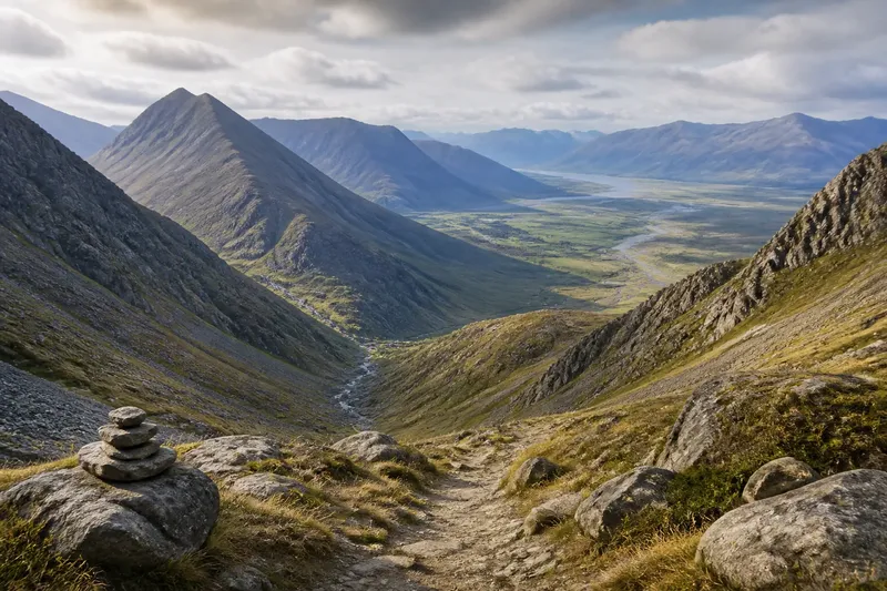
Why mountain passes become regional gateways is a question about the country on both sides, not a notch on a map. A pass may look like the obvious crossing between two regions, yet its influence depends on where its approaches lead, what obstacles surround it and whether people can reach it from settled ground.
To understand a pass as a route, follow the whole corridor: from the inhabited lowlands, through the narrowing valleys, over the divide and down towards the next usable district. The saddle itself is only one link. A doorway set into a wall is useful only if there is a room on either side; mountain geography is less tidy, but the principle holds.
Read the whole corridor
Begin with the larger shape of the land. Identify the watershed, the principal valleys and the mountain ridges that separate them. A pass matters when it connects drainage basins or inhabited areas that would otherwise require a long detour around the range. Its position on the crest is less revealing than the routes that converge below it.
On a map, trace each approach backwards. Does a valley run inland towards farms, a market town or a river crossing? Does the opposite descent continue towards another settlement, or end in a steep-sided basin? A crossing with a clear approach on one side and a poor exit on the other may be locally useful without serving as a regional gateway.
Look at the alternatives, too. A pass can channel movement because nearby ridges are higher, cliffs interrupt the valley, or waterways make a detour awkward. If several low routes offer comparable access, movement may spread among them rather than gather at one crossing. The pass is not inherently central; the surrounding terrain makes it so, or does not.
Follow the approaches
The climbing route can matter as much as the elevation at the top. A broad valley floor gives travellers a relatively continuous approach. A gorge, unstable slope or sequence of side valleys can make the same crossing difficult to reach, even if the pass itself appears modest. On the far side, the descent may open into a connected network or leave the traveller facing another barrier.
Check how the route meets water. Rivers may guide movement along a valley, but their crossings can funnel traffic to particular points. A bridge, ford or narrow gorge can become the practical hinge between the valley floor and the ascent. Where the route has to leave the river, note whether a side valley provides a natural turn or whether it demands a sharp climb across a ridge.
Relief maps and contour lines help reveal these connections. A road map can show a route already selected by people, while a topographic map helps explain why that route may have been chosen. Compare both, then inspect satellite imagery for visible valley floors, exposed slopes and built-up areas. These sources show terrain and present-day access, not every past condition, so treat them as clues rather than a record of historical traffic.
Let the terrain set the routine
A useful field or desk-based reading can follow the landscape over one week. The routine is deliberately modest: each day answers a different question, and the notes accumulate into a route description rather than a single claim that the pass was “important”. Choose one pass and keep the same map scale throughout, so local details remain comparable.
- Monday, mark the divide. Trace the ridgeline and the valleys that drain away from it. Note the nearest alternative crossings and the larger barriers between them.
- Tuesday, trace the western approach. Follow the route from the pass to the nearest settlements, river crossings and usable valley floors. Record where the line narrows or branches.
- Wednesday, trace the eastern approach. Repeat the same process on the other side. Ask whether it reaches a connected region or stops at another terrain bottleneck.
- Thursday, compare alternatives. Follow neighbouring passes and routes around the range. Note which approach is shorter in geographical terms, and which appears to offer a more continuous corridor.
- Friday, add human access. Mark roads, paths, bridges, settlements and visible land use. Separate present-day infrastructure from the natural route it may follow.
- Saturday, check the ground if appropriate. Observe the valley shape, water crossings and slope conditions from established public routes. Do not treat a map-based inference as a reason to enter unsafe or restricted terrain.
- Sunday, write the connection. Describe what the pass links, what constrains movement and where the route could be diverted. Keep uncertainty visible rather than filling gaps with a confident story.
Say you are tracing an invented pass between two northern valleys. The map shows a low saddle, but the western side ends above a narrow gorge while the eastern side opens onto a broad river plain. You mark the gorge and compare another crossing upstream; the expected result is a clearer picture of where movement could gather, without assuming that the saddle alone dictated the route.
Separate access from importance
A pass can be physically accessible and still have limited regional reach. Perhaps its approaches serve only scattered upland settlements, or the descent leads to a district separated from wider routes by wetlands or another ridge. Conversely, a demanding crossing can matter if it is the most direct connection between two populated valleys and the alternatives require a substantial circuit.
Distinguish three questions in your notes: can people reach the pass, can they cross it under the conditions relevant to the period, and does the route connect places with reasons to exchange or travel? The first is about approach, the second about practical passage, and the third about regional relationships. A map can help with the first; answering the other two may require local records, place-name evidence or accounts of transport and settlement.
Season changes the answer. Snow, ice, rainfall and stream levels may alter which approaches are usable, while sheltered slopes and exposed ridges can behave differently at the same elevation. A route that serves nearby communities in one part of the year may be unsuitable for longer journeys at another time. Avoid treating a modern road’s year-round appearance as evidence that an older path was equally dependable.
What does the map leave out?
Does a low pass always carry more traffic?
No. A lower crossing can be difficult to reach or lead into an isolated basin, while a higher one may connect continuous valleys. Elevation is one part of the route, not a measure of its regional usefulness.
How can I tell whether a pass links two regions?
Trace both approaches to their settlements, river networks and onward routes, then compare nearby alternatives. A regional link is more plausible when the corridor connects inhabited areas rather than stopping at another major obstacle.
Can a modern road explain an older route?
It can suggest which terrain offers a workable corridor, but it does not establish how people travelled in another period. Check for independent evidence such as older paths, crossing points or records, and keep the distinction clear.
Why might a pass matter locally but not regionally?
It may connect neighbouring upland communities without linking them to a wider network. Its role can be meaningful at a local scale even when another crossing carries the broader connection.
Describe the connection precisely
When writing about why mountain passes become regional gateways, name the places or valleys at either end and explain the obstacles that make the route useful. Say whether the pass offers a direct corridor, gathers routes from side valleys or merely avoids a longer circuit. That wording tells a reader more than calling it a natural gateway and leaving the geography to do the work.
Keep the scale of the claim matched to the evidence. A contour map may support a description of terrain; a road map may show current access; neither alone establishes how much movement a pass carried in the past. Where the evidence is incomplete, describe the route’s potential and the conditions that would support it, rather than assigning it a historical importance that the landscape cannot prove.
The most useful final check is to trace the route beyond the summit in both directions. If each descent leads into a connected valley system, the pass may function as a regional gateway; if one side quickly meets another barrier, its reach is narrower. The map’s most informative feature may be not the saddle itself, but the next obstacle after it.